• For more information on how to avoid pop-up ads and still support SkiTalk click HERE.

nay

dirt heel pusher
Skier
Joined
Dec 1, 2015
Posts
6,515
Location
Colorado
I don’t worry too much for northern Colorado, given we are usually in a crossroads position for storms sliding down the backside of big west coast ridges.

Son of Blob has large coverage, but not the warm water depth of the last event (yet). The storm pattern is pretty active for this time of year, but hopefully it won’t snow much now, since that all will have to come down anyway.

With the storm track to the north, it’s fire danger here. I took this on Sunday driving by the northern Sangre de Christos.

09581AD4-4C93-442B-992B-57A892783C40.jpeg
 

jack97

Out on the slopes
Skier
Joined
Jul 7, 2017
Posts
924
The Blob looks like its slowly dying.....

anomnight.9.26.2019.gif


Up north.... the early snow cover will make for a weak AO, meaning the polar jet stream will dip further south into the contiguous US.

ims2019270_alaska.gif
 

slowrider

Trencher
Skier
Joined
Dec 17, 2015
Posts
4,562
Mid teens at night next week. That's unseasonably cold for the PNW.
 

slowrider

Trencher
Skier
Joined
Dec 17, 2015
Posts
4,562
I have a good feeling about this season. Hoping no anomalies get thrown in the trend.
 

Tom Co.

life's new window
Skier
SkiTalk Supporter
Joined
Apr 14, 2016
Posts
638
Location
Seattle
More good news for the PNW
The forecast total through 5 AM tomorrow (Wednesday) shows snow above roughly 3300 ft, with up to a half-foot in favored locations. The Rockies and its eastern slopes get hit hard again

And for snow/cold lovers I have more good news. The Blob offshore is weakening with sea surface temperatures off the Northwest coast returning to near normal.

Want more good news? The latest European Center 46-day forecast is going for colder than normal temperatures through November 22 (see below, blue color is below-normal temperatures). Time to wax your skies.
ecmwf-conus-t2m_f_anom_46day-4380800.png
 

David Chaus

Beyond Help
Skier
Team Gathermeister
SkiTalk Supporter
Joined
Nov 12, 2015
Posts
5,595
Location
Stanwood, WA
Here’s a blog post about this ^^^. Stevens received 10” as of the time of the post. Don’t know that much of it will stick around, but it has been staying pretty cold. It was 31 degrees this morning at my house, may get close to that overnight, and then warms up a little. And I’m pretty much at sea level, Stevens is at 4000’.

https://cliffmass.blogspot.com/2019/10/snowstorm-in-stevens-pass.html
 

cantunamunch

Meh
Skier
Joined
Nov 17, 2015
Posts
22,193
Location
Lukey's boat

David Chaus

Beyond Help
Skier
Team Gathermeister
SkiTalk Supporter
Joined
Nov 12, 2015
Posts
5,595
Location
Stanwood, WA
Why you not loading the touring gear?

First of all, I have clients booked up all week, secondly, I still have too much yard work to do, and thirdly......

.....I don’t have touring gear (insert “hanging my head in shame” emoji).
 

jack97

Out on the slopes
Skier
Joined
Jul 7, 2017
Posts
924
Siberia snow packs comes in early! Looks to be near 100% covered. Arctic sea extent is progressing...... I'm so glad the globul warming is causing more cooling :rolleyes:

ims2019285_alaska.gif
 

Jellybeans1000

Getting off the lift
Industry Insider
Joined
Apr 25, 2017
Posts
283
Location
Victoria, Australia
Siberia snow packs comes in early! Looks to be near 100% covered. Arctic sea extent is progressing...... I'm so glad the globul warming is causing more cooling :rolleyes:

ims2019285_alaska.gif
Well clearly you don't actually understand climate change...
 

Tom Co.

life's new window
Skier
SkiTalk Supporter
Joined
Apr 14, 2016
Posts
638
Location
Seattle
More from Prof Cliff Mass of the University of WA

The Blob is Weakening
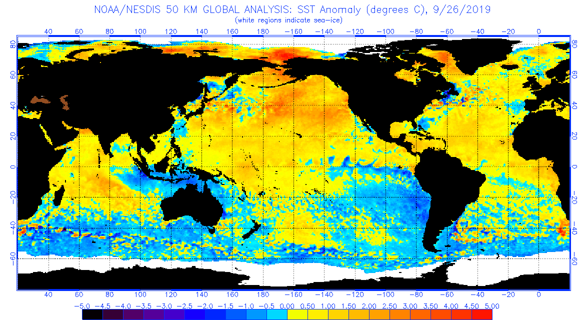
It is sad but true. The Blob, the area of above normal sea surface temperatures in the northeast Pacific, is weakening, particularly near the U.S. West Coast.
The plot of the sea surface temperature anomaly (difference from normal) for today (Wednesday) shows normal or even below normal sea surface temperatures along the west coast and extending well offshore of the Northwest. This is a major change over the past few weeks. A few months ago the sea surface temperatures off our coast were roughly 5F above normal. No more. There is still some BLOB warmth further offshore, but I suspect that will weaken over time now.
Another way to see that change is to look at one of the offshore NOAA buoys. Take buoy 46089 located off the Columbia River (see map)
In early September, the sea surface temperature at that location was up to around 67F, which is very warm. The temperatures have fallen to about 60F today, a large drop of 7F.
Other buoys have shown the same thing.
Why the change? The upper level flow pattern has changed dramatically. Well into September there was anomalous high pressure over the Pacific (red colors below, Sept 22-28). High pressure is associated with light winds and weaker than normal mixing in the upper ocean. With less mixing of cold water to the surface, the surface temperatures are above normal.
But the pattern has really changed recently, with below normal sea level pressure (low pressure systems with strong winds) now over the Gulf of Alaska. Bad for the BLOB.
We are now going into the stormy season for the North Pacific and it is unlikely that conditions will be good for the BLOB. Expect more weakening during the next week
And this is all good news. Excessively warm water in the NE Pacific is bad for the marine food chain, leading to poor salmon runs and other problems. So although the Blob may be sad, this is positive news for everyone else.

sst.daily.anom.gif


YES!
 

jack97

Out on the slopes
Skier
Joined
Jul 7, 2017
Posts
924
Contrary to propaganda, the Arctic sea ice extent is extending. The Albedo will be strong this season.
ims2019292_alaska.gif


With the Blob weakened, the question is whether the negative AO will cause banding that deters major storms to the NW resort areas.
ims2019292_usa.gif
 

Sponsor

Staff online

Top