- Joined
- Dec 21, 2015
- Posts
- 4,123
Stowe got 375inchs last time this happened and it wasnt cold...
")
There's a good chance we'll be at Stowe this winter...Stowe got 375inchs last time this happened and it wasnt cold...
I mean, it IS the weather after all!!As far as Joe Bastardi’s map, I remember him getting winter weather predictions WAY wrong back when he worked for Accuweather.
No, not everywhere.
It will only be Epic at VA resorts.
Hey, I use a little "e" intentionally!And VA resorts are always epic, as long as there's snow, and I'm there!
Epic vs IKONic - We're going to get a lot of skiing in.


Accuweather also had an article about the blob a week or so ago. Its position isn’t exactly the same as 2014-15, but I could see why it would create a blocking pattern. But isn’t this winter also an El Niño? That could make things less cut and dry, pun intended.
The blob did create an unprecedented cold and snowy weather pattern here in the Mid Atlantic.
As far as Joe Bastardi’s map, I remember him getting winter weather predictions WAY wrong back when he worked for Accuweather. I was teaching a meteorology class back then and his insistence on his forecasts got annoying as hell.
And, then, there’s this:
“Despite a warmer-than-average finish to the month being forecast for Alaska by the National Weather Service's Climate Prediction Center, the dome of high pressure fueling the blob is expected to shift and begin to deteriorate. This could allow in a stormier pattern, which may enable waters to blend where the blob sits, possibly weakening or destroying it.
The last time the blob appeared was in 2016, when multiple cold outbreaks were expected in its wake, but the blob was washed away.“
So, it’s too early for Westerners to worry and Easterners to rejoice.
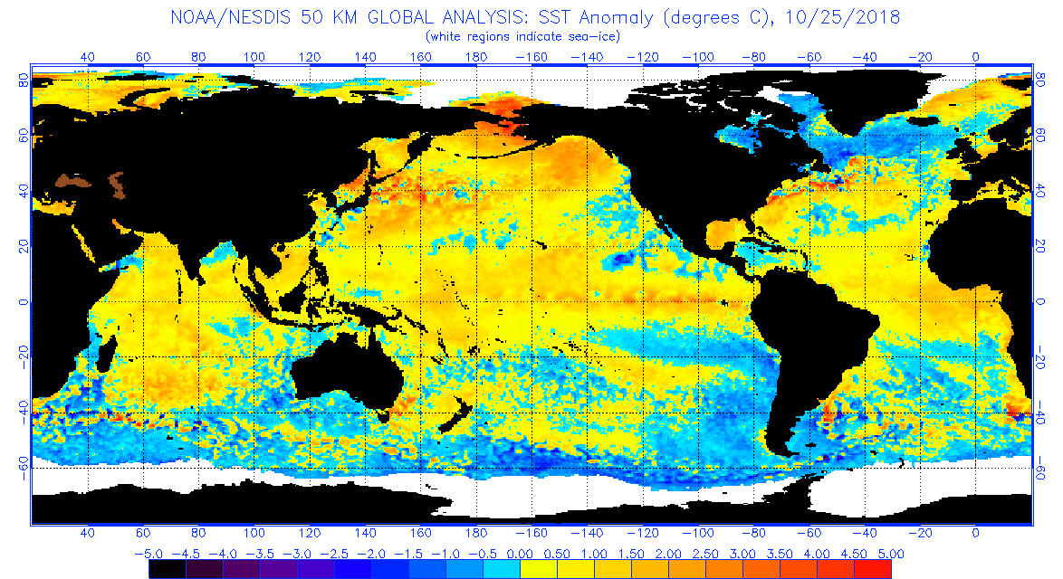
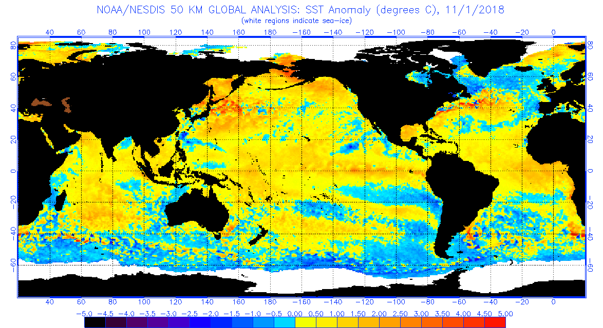
Pardon if I am being dumb, but aren’t the albedo effect and Arctic warming opposing forces? And wow...look at the SST anomaly in the Bering Strait....Latest sea surface anomaly, the Blob is still present, tho not as strong as past seasons. As for the east coast getting the goods, Greenland has accumulated more snow in the past year so the albedo effect and the Arctic warming will cause a weaken polar jet stream.
[/QUOTE]
Pardon if I am being dumb, but aren’t the albedo effect and Arctic warming opposing forces? And wow...look at the SST anomaly in the Bering Strait....
The year of the disaster winter, the water off San Diego was incredibly warm. Last year (which started badly and was a bad for Socal) had the water cool off late. This year, the water is chilly. No blob here. Good winter?!!!
Eric
I agree with that analysis. A reminder to all that we are looking at a centrally based El Niño, not a Modoki. There is unlikely to be cool anomalies during winter in Niño 1 + 2 (just off the South American Coast). This means a stronger subtropical jetstream, which means a good year for California in general in my opinion. Not so good for the PNW and BC, because of the "blob", which encourages strong highs in the Alaskan Gulf. We are also likely to see a strong Aleutian Low (because of Niño), which further amplifies the subtropical jet, and also causes stratospheric weakness, which helps out the Eastern US, down the track.Yesterday I saw one of the better tv weathermen in the Wash DC area (Topper Shutt) give his winter prediction for our area. He said a weak El Nino is expected and the mid-Atlantic should get more snow than normal. I think this means the southern Rockies (e.g. Taos) should also have a good year. We shall see??
Details here: https://www.wusa9.com/article/weath...ch-snow-you-can-expect-this-year/65-607294606
However ice in the Greenland sea to the east is lower than normal, so not sure whether relying on the low melting season in Greenland is going to help the intended effect. And the surrounding cold anomalies are going to hamper any major development of a -NAO. I'd far prefer a Barents-Kara ridge and -EPO mix, than a -NAO and -EPO separated form in terms of creating snowfall in the Eastern US.Greenland has accumulated more snow in the past year