• For more information on how to avoid pop-up ads and still support SkiTalk click HERE.

river-z

searching for seasons
Skier
Joined
Apr 24, 2017
Posts
243
Location
Riverside, CA
There was an article today in the LA Times about the blob.
https://www.latimes.com/environment/story/2019-09-05/second-blob-may-be-coming

This detail caught my attention:
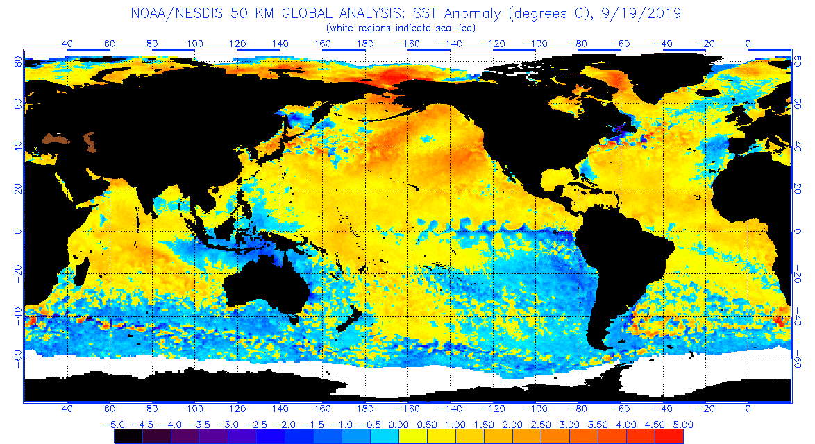
"Researchers said the 2019 marine heat wave could be even bigger than the blob, but it could also break apart.
“With the blob, the water was very warm down to 200 meters and even down below 500 meters,” said Toby Garfield, director of the environmental research division at NOAA’s Southwest Fisheries Science Center in La Jolla. “With this event right now, the heat is only in the top 50 meters, maximum.
If the low-pressure system moves and the winds increase, the heat wave might simply break apart. However, if the winds stay low and the mass of warm water reaches the coastline, it could have the same impact as the blob, scientists said.
 

John O

Getting off the lift
Skier
Joined
Nov 21, 2015
Posts
423
Location
Seattle, WA
I really really really really really hope the blob isn't actually back, and/or dissipates quickly. It was absolutely brutal for the PNW snowfall and snowpack in 14/15. I do not want that kind of winter again so soon.
 

Eleeski

Making fresh tracks
Skier
Joined
Nov 13, 2015
Posts
2,299
Location
San Diego / skis at Squaw Valley
Weather is extremely complex and chaotic. Popularizing one small factor like the Blob is misguided. (See the first pages of this thread - predictions of doom in a year where we skied on the Fourth) I hope nobody cancels a planned trip this winter based on having warm swimming water in San Diego right now.

The established common knowledge is not perfect. La Ninas aren't always dry. El Ninos aren't always wet. Global warming will not end skiing. Sacrificing Mayan children will not end droughts.

Eric
 

Ken_R

Living the Dream
Skier
Joined
Feb 10, 2016
Posts
5,775
Location
Denver, CO
Screen Shot 2019-09-09 at 9.46.12 AM.png
 

robertc3

Out on the slopes
Skier
Joined
Sep 12, 2017
Posts
515
Location
Kenmore, WA
It is worrisome the blob has formed, but it could dissipate with just a couple of good storms to churn up the water in the eastern pacific. September is too early to start worrying about something that can so easily change in one month. If the blob is still around on 12/1 then it will be time to start booking airline tickets for us northwesterners.
 

martyg

Making fresh tracks
Industry Insider
Joined
Nov 24, 2017
Posts
2,235
The last time that The Blob formed it totally screwed the PNW. If I remember correctly, CO got hammered.

This is a pic of Mt Baker Ski Area that winter. At the time that I took and posted, many thought it was the parking lot. It is an open ski run - and one of the runs that actually had coverage. This shot was taken mid-Feb. For perspective, I believe that Mt. Baker's running average on snowfall was 735", prior to this winter. That winter screwed the pooch on yearly averages.

Mt-Baker-02-10-15-1.jpg
 

Jerez

Skiing the powder
Skier
SkiTalk Supporter
Joined
Nov 25, 2015
Posts
3,046
Location
New Mexico
The Farmer's Almanac was one of the few that got it sorta right last year and I like that map, so I'm sticking with that.
'Cause, you know, screw science and go with what you want to believe. :rolleyes:
 

slowrider

Trencher
Skier
Joined
Dec 17, 2015
Posts
4,562
The last time that The Blob formed it totally screwed the PNW. If I remember correctly, CO got hammered.

This is a pic of Mt Baker Ski Area that winter. At the time that I took and posted, many thought it was the parking lot. It is an open ski run - and one of the runs that actually had coverage. This shot was taken mid-Feb. For perspective, I believe that Mt. Baker's running average on snowfall was 735", prior to this winter. That winter screwed the pooch on yearly averages.

Mt-Baker-02-10-15-1.jpg
Bachelor free base grind.
Bgrind.jpg
 

jack97

Out on the slopes
Skier
Joined
Jul 7, 2017
Posts
924
What would that chart show historically? Are you saying there is more ice than normal? Or less?

The map shows the daily snow cover over the northern hemisphere. With an early snow pack starting in the fall season, this sets up a high air pressure region for the coming winter season. Stated another way, a large area snow pack forces hot air to reflect back up the atmosphere due to the snow's albedo effect. This results in a high air pressure region over the Arctic, thus a weaken polar vortex, so cold winds and temperature will dip more southerly to the contiguous US.

The above couple with the Blob sets up "ridges" where the cold fronts and storms will travel across the US. The fall snow pack effect has been discovered and still analyzed for about the last ten years or so. The Blob which sets up a blocking pattern to the NW region is a more recent phenomenon.

Latest map, snow cover is happening......

ims2019255_alaska.gif
 
Last edited:

dbostedo

Asst. Gathermeister
Moderator
Contributor
SkiTalk Supporter
Joined
Feb 9, 2016
Posts
18,375
Location
75% Virginia, 25% Colorado
BTW, with the fall solstice a week away, up at the Arctic...

Can you expand on that? What's the significance? I think it's been a pretty low year for sea ice to this point, right? How does that affect things?
 

jack97

Out on the slopes
Skier
Joined
Jul 7, 2017
Posts
924
^^^

The significance of the fall solstice is its the start of fall in terms of astronomic season, earth's location as it orbit around the sun. In addition, it turns out that its close to when the Arctic sea ice will starts its extent. The links below shows an interactive graph of the Arctic sea ice extent, this season has warm waters in the region hence the sea ice extent was low, however it will most likely not exceed the record of lowest sea ice extent which was observe back 2012. BTW, it shows historic graphs for sea ice extent for the Antarctic as well.

http://nsidc.org/arcticseaicenews/charctic-interactive-sea-ice-graph/


In addition, Sept is when scientist starts charting ice/snow accumulation on Greenland. Where and the intensity of the albedo effect is determine by the location of the snow and ice. The early forecast by Bastardi suggest a weaken polar vortex, meaning the Arctic air pressure will be high.

SMB_combine_SM_acc_EN_20190914.png
 

jack97

Out on the slopes
Skier
Joined
Jul 7, 2017
Posts
924
Blob appears to be getting weaker. Sea Surface Temperature Anomaly (long term average for the month) shows less warmth as compare to a month ago.

anomnight.9.19.2019.gif


Mean while, further up north, the snow cover is on. :yahoo:
ims2019262_alaska.gif
 

Sponsor

Staff online

Top