• For more information on how to avoid pop-up ads and still support SkiTalk click HERE.
Status
Not open for further replies.

Freaq

Pretends to be local
Skier
Joined
Jan 10, 2016
Posts
310
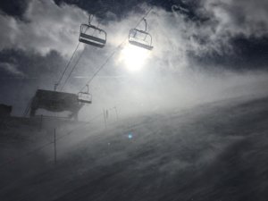
Long lasting crowd today. Stupor Bowl usually makes for lonely slopes in the afternoon but not even a dark squall after a sunny day eliminated the lines at the six pack. Mostly rode the old double, made a bump day of it.
https://www.relive.cc/view/2122812055
 

tball

Unzipped
Skier
SkiTalk Supporter
Joined
Nov 12, 2015
Posts
4,371
Location
Denver, CO
This was the result of the Best Snowstake for Less than $20 competition.
At least they remembered to put numbers on it, unlike A-basin!

@Ken_R it looks a lot like the old spot in the trees near the top of the Eagle. Presumably, they moved it to the bar for the lift construction.

Classic Copper picture from Saturday:
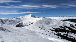
IMG_20190202_114918.jpg

And a few pics from a mogul comp on Rossie's Run that I enjoyed watching for a bit. It was fun to see the kids getting after it!
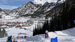
IMG_20190202_111240.jpg

Note the Ikonic line at the Super Bee ^^^. It was 11 am on a sunny Saturday before the Super Bowl, so hoping it was just a fluke.

Really pretty inverted. Wish I'd taken it from up above like the prior shot.
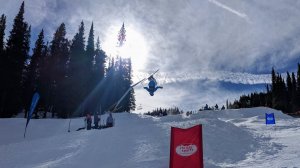
IMG_20190202_111429.jpg

Then had some fun runs with @UGASkiDawg but no pics as I was just trying to keep up!
 

surfandski

Out on the slopes
Skier
Joined
Mar 5, 2017
Posts
708
Location
Clearwater Beach, Fl and Pisgah Forest, NC
I've been looking at the forecasts and trying to guesstimate where the best snow will be this cycle (sounds like West-Central). I don't have enough time to head South to Wolf or Durango and Monarch doesn't appear to show much more than I70. Sunlight and Powderhorn are both showing bigger totals and both are on the Loveland pass so I'm thinking of hitting one or both of those on Wednesday and Thursday. Are they both worth checking out or would I be better off hitting one of those two days in a row (I'm staying at the Hot Springs)? Powderhorn's forecast is looking a little better though but I can make the final call tomorrow night. Thanks!
 
Last edited:
Thread Starter
TS
nay

nay

dirt heel pusher
Skier
Joined
Dec 1, 2015
Posts
6,515
Location
Colorado
I've been looking at the forecasts and trying to guesstimate where the best snow will be this cycle (sounds like West-Central). I don't have enough time to head South to Wolf or Durango and Monarch doesn't appear to show much more than I70. Sunlight and Powderhorn are both showing bigger totals and both are on the Loveland pass so I'm thinking of hitting one or both of those on Wednesday and Thursday. Are they both worth checking out or would I be better off hitting one of those two days in a row (I'm staying at the Hot Springs)? On a map, Sunlight looks a lot further yet it is almost an hour closer than Powderhorn. Powderhorn's forecast is looking a little better though but I can make the final call tomorrow night. Thanks!

I dunno, maybe stay local ogsmile

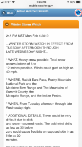
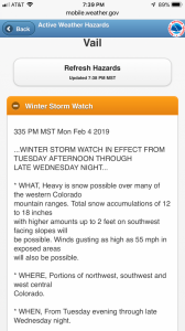
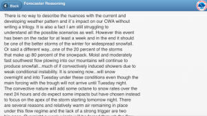
021B70AB-6FFF-491F-8155-1474A114CA20.png

Although anything in the western slope...

1F6506A9-18B4-425A-B4C9-EE9EEE32FB54.png

I don’t read much from the Grand Junction forecast office, but they are fun when they get excited.

444E67AF-35F4-433A-A6F9-A4489C5B0E62.png

Making a final call tomorrow night sounds like staying in place, though, since it looks like things start tomorrow afternoon.
 
Last edited:

surfandski

Out on the slopes
Skier
Joined
Mar 5, 2017
Posts
708
Location
Clearwater Beach, Fl and Pisgah Forest, NC
Thanks Nay! That's so strange unless the forecast just updated this evening. Using weather.gov (mobileweather.gov) for Bakerville (which I believe is the same location you use) it is showing about half of what the west central mountains are supposed to get. I just looked at it again and it is saying 1" tonight, 1/2" tomorrow and 1-3 Tuesday night. When I click on the bar graph it is showing snow for tonight and tomorrow that wasn't there earlier today so it does seem that it's ramping up some but the forecast discussion does not seem as intense as what you posted above. We are skiing Loveland tomorrow and then I'll decide if I'm heading cancelling my reservations in Glenwood Springs. I may go regardless as chair 9 will not likely spin until Friday and I'll definitely want to be back for that. Hopefully the morning forecasts will bring more clarity.
 

TexasStout

Epic Pass + Loveland 4-pack for 2021-2022
Skier
Joined
Nov 24, 2015
Posts
698
Location
Texas and Colorado
Thanks Nay! That's so strange unless the forecast just updated this evening. Using weather.gov (mobileweather.gov) for Bakerville (which I believe is the same location you use) it is showing about half of what the west central mountains are supposed to get. I just looked at it again and it is saying 1" tonight, 1/2" tomorrow and 1-3 Tuesday night. When I click on the bar graph it is showing snow for tonight and tomorrow that wasn't there earlier today so it does seem that it's ramping up some but the forecast discussion does not seem as intense as what you posted above. We are skiing Loveland tomorrow and then I'll decide if I'm heading cancelling my reservations in Glenwood Springs. I may go regardless as chair 9 will not likely spin until Friday and I'll definitely want to be back for that. Hopefully the morning forecasts will bring more clarity.
Opensnow has come back with recent updates which are double on the Tuesday night/Wednesday morning numbers that have been out for awhile.
 
  • Like
Reactions: nay
Thread Starter
TS
nay

nay

dirt heel pusher
Skier
Joined
Dec 1, 2015
Posts
6,515
Location
Colorado
Thanks Nay! That's so strange unless the forecast just updated this evening. Using weather.gov (mobileweather.gov) for Bakerville (which I believe is the same location you use) it is showing about half of what the west central mountains are supposed to get. I just looked at it again and it is saying 1" tonight, 1/2" tomorrow and 1-3 Tuesday night. When I click on the bar graph it is showing snow for tonight and tomorrow that wasn't there earlier today so it does seem that it's ramping up some but the forecast discussion does not seem as intense as what you posted above. We are skiing Loveland tomorrow and then I'll decide if I'm heading cancelling my reservations in Glenwood Springs. I may go regardless as chair 9 will not likely spin until Friday and I'll definitely want to be back for that. Hopefully the morning forecasts will bring more clarity.

Western Slope looks 2-3x totals based on morning forecast runs. Could be worth chase. No wind, fortunately :roflmao:

27FBFA5F-6FAD-450D-9ACE-10CA5B867C60.jpeg
 
Last edited:

surfandski

Out on the slopes
Skier
Joined
Mar 5, 2017
Posts
708
Location
Clearwater Beach, Fl and Pisgah Forest, NC
Loveland was good today but windy as expected. The good news is the family had fun and just brushed off the wind like it was no big deal and really enjoyed the cream cheese powder which is real progress.

I'm heading west but still haven't decided if I'll ski both Powderhorn and Sunlight or just Sunlight back to back days. I'd appreciate any experience from those who have skied both. I'll probably hit one of each unless one gets substantially more snow. Friday at Loveland should be tasty as well! Thanks!
 
Thread Starter
TS
nay

nay

dirt heel pusher
Skier
Joined
Dec 1, 2015
Posts
6,515
Location
Colorado
We weren’t finding much consistent at A-Basin with heavy wind scouring and a lack of good deposits...

37CC62F1-7B5E-4685-9F1E-FED2EC82E3ED.jpeg

...so we headed over the pass where I’d feared Luv was overly scoured. Fortunately, my fears weren’t founded. Scoured, but with good deposits.

A803F92A-3B65-40CC-AF06-0A38469E9BB7.jpeg

9 was actually running in the high wind today and Castle Rock and the south side of Primer had been looking good yesterday before the wind hold. Seen here as typically heavily tracked :ogcool:

1E85DFED-244B-4FE4-BFAF-C7C0D0B00E7F.jpeg

Deposits. With some patches down lower to straighten out those arcs.

1B7ABFB8-8ADA-4300-8963-E81856D864F5.jpeg

But not enough to stop some lapping.

B831A4ED-AE80-4607-BE64-724B0139F757.png

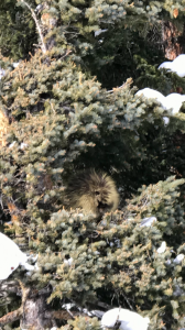
And lil P was out again.

4EA32FB9-B81D-47A5-9515-9AE444C8BA4E.jpeg
 

Freaq

Pretends to be local
Skier
Joined
Jan 10, 2016
Posts
310
The wind swept this one up and threw it down all helter skelter. It was a freaqy Friday Tuesday where the conditions that I look for on the right side of a run turned up on the left, the conditions that are prevalent on the top of a run were present at the bottom in spades. I skied thick breakable crust and after a couple hesitant turns, enjoyed the heck out of it. We rode the six pack to the top in screaming winds to find that the usually filled in canyon was dust on refrozen chowder. Skied refrozen corduroy that had lots of wind buff about three inches deep and also had lots of....refrozen cord... no one in front of me, skied that one really fast = )

https://www.relive.cc/view/2126839041
 
  • Like
Reactions: nay
Thread Starter
TS
nay

nay

dirt heel pusher
Skier
Joined
Dec 1, 2015
Posts
6,515
Location
Colorado
Skied refrozen corduroy that had lots of wind buff about three inches deep and also had lots of....refrozen cord... no one in front of me, skied that one really fast = )

I think “really fast” was theme of the day. Making arcing turns from cream into funk didn’t produce spectacular results :P
 
Thread Starter
TS
nay

nay

dirt heel pusher
Skier
Joined
Dec 1, 2015
Posts
6,515
Location
Colorado
Thanks Nay! That's so strange unless the forecast just updated this evening. Using weather.gov (mobileweather.gov) for Bakerville (which I believe is the same location you use) it is showing about half of what the west central mountains are supposed to get..

I do use Bakerville on the mobile site, which irritates me because I used to be able to input Loveland Pass, which is a much better correlation. Bakerville is just far enough down the mountain to have precip shut off in westerly flow when it’s hammering the upper mountain. But then, less info for the masses is more.

The full website still lets you zoom in and select a more localized forecast. I pretty much go with “any snow in Bakerville means a lot of snow above treeline at Luv”.

This storm is interesting. I have a hunch that both A-Basin and Luv are going to overperform as they do well in WSW flow as the flow transitions. We’ll see.
 
Status
Not open for further replies.

Sponsor

Top