• For more information on how to avoid pop-up ads and still support SkiTalk click HERE.

Comparing Latitude and Elevation at Western US Resorts

Jim McDonald

愛スキー
Skier
Joined
Nov 15, 2015
Posts
2,101
Location
Tokyo
Hmmm, I'll put Niseko's mid-season snow up against anyplace in terms of quantity & quality (tho granted the real pow season is fairly short).
The lifts top out at 1,200m (3,900'), the Sea of Japan is about 30km (20 miles) away, and the mountain is at about 43*N.
I think maybe there's a few more factors that need consideration.
 

sbooker

Getting on the lift
Skier
Joined
Apr 24, 2017
Posts
256
Hmmm, I'll put Niseko's mid-season snow up against anyplace in terms of quantity & quality (tho granted the real pow season is fairly short).
The lifts top out at 1,200m (3,900'), the Sea of Japan is about 30km (20 miles) away, and the mountain is at about 43*N.
I think maybe there's a few more factors that need consideration.

Yeah. Like the Siberian breeze factor. ogsmile
Kinda unique.
 

sbooker

Getting on the lift
Skier
Joined
Apr 24, 2017
Posts
256
I was talking to Tony C by email and his view is every one degree of latitude is roughly ‘equal to’ 250 feet of elevation - not 500 feet.
For what it’s worth Tony’s top snow preservation scores go to -
A Basin
Taos
Crested Butte
Wolf Creek
Copper
Telluride
Aspen Highlands
Mammoth
Snowbird
Snowmass
Winter Park
Aspen Mountain

I asked him why Breck and Loveland didn’t feature in that top dozen and he said (to paraphrase) that the easterly orientation worked against them but he also mentioned they were certainly good spring skiing mountains.
 

Jim McDonald

愛スキー
Skier
Joined
Nov 15, 2015
Posts
2,101
Location
Tokyo
Like the Siberian breeze factor.
Oh yeah! :D
 

James

Out There
Instructor
Joined
Dec 2, 2015
Posts
24,980
This might explain the Alps a bit.
Example
Val d'Isere, France 45.4 deg N
Verbier, Switzerland is 46.1 deg N
St Anton, Austria 47.1

Abasin 39.6
Taos 36.4
Big Sky 45.3
 

Sibhusky

Whitefish, MT
Skier
Joined
Oct 26, 2016
Posts
4,828
Location
Whitefish, MT
This might explain the Alps a bit.
Example
Val d'Isere, France 45.4 deg N
Verbier, Switzerland is 46.1 deg N
St Anton, Austria 47.1

Abasin 39.6
Taos 36.4
Big Sky 45.3
You're saying that in the Alps all the resort's are at roughly the same latitude, but resorts here are spread out widely?

Edit. I'm just asking what point you're making here. As is clear later in the discussion, I missed it.
 
Last edited:
Thread Starter
TS
N

New2

Out on the slopes
Skier
Joined
May 3, 2017
Posts
729
Location
Spokane
I was talking to Tony C by email and his view is every one degree of latitude is roughly ‘equal to’ 250 feet of elevation - not 500 feet.

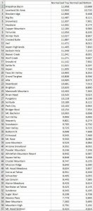
That sounds maybe more accurate... updated comparison with that 250' per degree Tony suggested:

250skilatitude.jpg

I'm thinking this looks closer to right than 500' per degree. The far-north and far-south resorts aren't showing as extremely now, and seem to be a bit more closely in line with comparable spots. But I think this might be going a bit too far... @David Chaus mentioned that Stevens Pass seems generally comparable to Tahoe (and I'd concur, but based on very limited experience), but 250' per degree leaves both the base and top at Stevens showing warmer than Tahoe areas. Whitefish and Schweitzer show warmer than AZ Snowbowl, all of Utah, and most of Tahoe... I haven't been to Whitefish or Schweitzer, but by reputation I think this is likely not accurate.

I asked him why Breck and Loveland didn’t feature in that top dozen and he said (to paraphrase) that the easterly orientation worked against them but he also mentioned they were certainly good spring skiing mountains.

Yeah, exposure makes a significant difference.

This might explain the Alps a bit.
Example
Val d'Isere, France 45.4 deg N
Verbier, Switzerland is 46.1 deg N
St Anton, Austria 47.1

Abasin 39.6
Taos 36.4
Big Sky 45.3

Europe's low-angle sunlight is definitely good for ski conditions, but thanks to the Gulf Stream, it's a radically different climate than western North America.
 

Sibhusky

Whitefish, MT
Skier
Joined
Oct 26, 2016
Posts
4,828
Location
Whitefish, MT
I don't think our snow quality is that different than Big Sky, and we've got more of it. Visibility, sure, they have it. Maybe some factor about east or west of the divide? We're west, they're east.
 
Thread Starter
TS
N

New2

Out on the slopes
Skier
Joined
May 3, 2017
Posts
729
Location
Spokane
I don't think our snow quality is that different than Big Sky, and we've got more of it. Visibility, sure, they have it. Maybe some factor about east or west of the divide? We're west, they're east.

Well, assuming no rain (and I think both resorts are high enough that rain is rarely a problem), the biggest difference I'd expect to see in snow quality based on the latitude/altitude differences would be better preservation in the springtime at Big Sky. Looks like TonyC's notes bear this out... for best time to ski at Whitefish he says "January/February for coverage, surface conditions, powder." For Big Sky, "Mid-January to mid-March for Lone Peak coverage. Sunny spring exposures, but highest and coldest terrain in region aids snow preservation." It's also worth noting that the top 1,400 vertical feet or so at Big Sky is limited to something like 5% of the terrain, on Lone Peak under the tram. So the other 95% of the terrain is closer to Whitefish's normalized elevation. Though I still think a ratio that penalizes Whitefish less is probably appropriate.
 

Lofcaudio

Getting off the lift
Skier
Joined
Apr 27, 2017
Posts
344
Location
Columbia, Missouri
I would argue that the combination of latitude and elevation is going to arrive at TEMPERATURE more than anything else, but only within the same geographic region.
 

surfacehoar

Getting off the lift
Skier
Joined
May 12, 2017
Posts
185
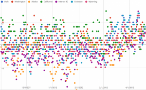
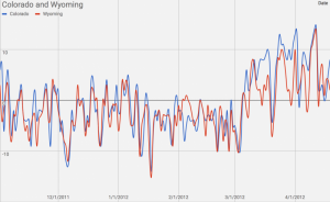
I was interested in comparing different resort locations a few years back so I took the time to gather some temperature data from the snowplots of a few select locations. I focused on maximum temperature. Understanding that the freezing point being the most critical metric for snow melt/preservation. This accounts for warm days, warm weather systems(rain), as well as temperature inversions.

The snow plots were selected due to their elevation in respect to peak chairlift elevation for the given location. The snowplots used were: A-basin, Grand Targhee, Snowbird, Squaw Valley. St. Leon(interior BC) Paradise (Washington), Alyeska.

Maximum temperatures for the 2011/12 snow season.

Screen Shot 2018-06-04 at 11.20.27 AM.png

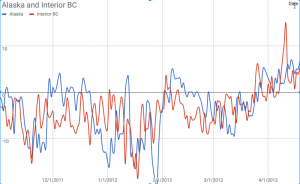
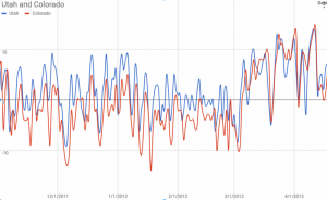
I apologize for such a messy graph. In summary, there weren't many surprises. Washington and California were the warmest locations. Alaska was the most extreme/variable. Wyoming has a slight edge over Colorado. Utah was warmer than Colorado and Wyoming. Interior of BC was the most consistent cold.

Something worth noting is how latitude influences seasonal change and temperature. The further north the greater the seasonal change.


Some direct comparisons:

Screen Shot 2018-06-04 at 12.23.34 PM.png Screen Shot 2018-06-04 at 12.21.49 PM.png Screen Shot 2018-06-04 at 12.20.26 PM.png
 
Last edited:
Thread Starter
TS
N

New2

Out on the slopes
Skier
Joined
May 3, 2017
Posts
729
Location
Spokane
I was interested in comparing different resort locations a few years back so I took the time to gather some temperature data from the snowplots of a few select locations. I focused on maximum temperature. Understanding that the freezing point being the most critical metric for snow melt/preservation. This accounts for warm days, warm weather systems(rain), as well as temperature inversions....

Neat project! It'd be cool to get this sort of data spread across multiple seasons... California in particular likely shows worse in this graph than it would in a historically-normal season (though there have been few enough of those lately to raise the question of whether drought is the new normal). For the vertical axis, is it showing degrees Celsius? Or something else?
 

Jacob

Out on the slopes
Skier
Joined
Oct 13, 2017
Posts
777
Location
Maui
You're saying that in the Alps all the resort's are at roughly the same latitude, but resorts here are spread out widely?

That's pretty much the case. The Alps run in a west-southwest to east-northeast direction, with a bit of an arc in the southwestern corner. So, there's quite a bit of east-west spread, but not much north-south. Imagine the Rockies running roughly east-west rather than roughly north-south.

But, the Alps are just one of the ranges in Europe, while the list of US resorts includes a few different ranges. A Europe-wide comparison would include resorts in the Pyrenees as well as Norway and Sweden, and that would give a pretty good north-south spread.
 
Last edited:

surfacehoar

Getting off the lift
Skier
Joined
May 12, 2017
Posts
185
Neat project! It'd be cool to get this sort of data spread across multiple seasons... California in particular likely shows worse in this graph than it would in a historically-normal season (though there have been few enough of those lately to raise the question of whether drought is the new normal). For the vertical axis, is it showing degrees Celsius? Or something else?

The V-axis is degrees C. I'd like to look at more seasons, I remember this being quite tedious. So we will see how far I get.
 

Sibhusky

Whitefish, MT
Skier
Joined
Oct 26, 2016
Posts
4,828
Location
Whitefish, MT
closed-mouth%5B1%5D.png
 

James

Out There
Instructor
Joined
Dec 2, 2015
Posts
24,980
You're saying that in the Alps all the resort's are at roughly the same latitude, but resorts here are spread out widely?
No, just that they were pretty far north.
Altitude is not that high. Most sking takes place between what, 1,500m and 2,500 m? Say roughly 4,900-8,200ft

Though I don't think the snow quaity is all that great up in Sweden, Norway or Finland but I really have no idea.
I would hardly book a trip to Sweden over Utah for snow quality and never have heard people raving about the snow there. But, maybe it's amazing.

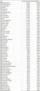
That sounds maybe more accurate... updated comparison with that 250' per degree Tony suggested:
View attachment 47018
I'm thinking this looks closer to right than 500' per degree. The far-north and far-south resorts aren't showing as extremely now, and seem to be a bit more closely in line with comparable spots. But I think this might be going a bit too far... @David Chaus mentioned that Stevens Pass seems generally comparable to Tahoe (and I'd concur, but based on very limited experience), but 250' per degree leaves both the base and top at Stevens showing warmer than Tahoe areas. Whitefish and Schweitzer show warmer than AZ Snowbowl, all of Utah, and most of Tahoe... I haven't been to Whitefish or Schweitzer, but by reputation I think this is likely not accurate.

Yeah, exposure makes a significant difference.

Europe's low-angle sunlight is definitely good for ski conditions, but thanks to the Gulf Stream, it's a radically different climate than western North America.
How is this calculated?
I'm looking at Abasin and Loveland.
Abasin base is 10,780 ft base, latitude 39.6degN
Loveland base 10,800 latitude latitude 39.7 deg N
Yet, corrected it's
Abasin 10,688
Loveland 10,720

1/10th a degree latitude should be 25 feet, no?

When doing a table like this the starting values should be in it.

IMG_5319.JPG
 

surfacehoar

Getting off the lift
Skier
Joined
May 12, 2017
Posts
185
My focus was to look at powder preservation which I think differs from snowpack perseveration. Places with drier climates will have a much greater temperature change throughout the day. While humid locals will have a more similar temperature from night to day.

Cold nights transfer to the snowpack, it's more capable of withstanding the days warm.

With solar radiation, it's clear that shaded slopes will be less effected. South slopes getting the most sun. It makes sense in my brain, but i'm not sure if it's true that the further north you go, due to the tilt of the axis of the earth. South slopes line up more directly with the sun. Although the sun isn't as strong, the angle is more direct resulting in more solar radiation during times of sunlight. Think of a flashlight shining in the your face vs down on top of your head. Of course, this probably means that faces get even less radiation at higher latitudes.

Snowpack density is also a major factor to consider.
 

Sibhusky

Whitefish, MT
Skier
Joined
Oct 26, 2016
Posts
4,828
Location
Whitefish, MT
Might be nice to see that re-sorted by normalized bottom (or average). Because the acreage at the bottom is higher than the acreage at the peak.
 
Last edited:

Sponsor

Staff online

Top