• For more information on how to avoid pop-up ads and still support SkiTalk click HERE.

Daniel

Out on the slopes
Skier
Joined
Jun 27, 2017
Posts
535
Location
Cottonwood Heights, Utah
Photo is of Sundial Peak from Lake Blanche, BCC. Highest peak to the left and in the background of Sundial is Mt. Superior.

IMG_0043.JPG


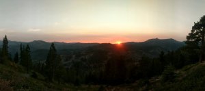
Cottonwood Ridge from Lake Blanche.

IMG_0044.JPG


High peaks from left to right along Cottonwood Ridge are Dromedary, Sunrise, and Broads Fork East Twin Peak.

IMG_0042.JPG
 

James

Out There
Instructor
Joined
Dec 2, 2015
Posts
24,967
64218FC7-B677-46C5-B038-6D46C71EC5BB.jpeg

Hike up near White Rocks, Wallingford, VT. Way upper right if you zoom in you can see Rutland airport.

5227395E-8FE8-4759-BFBE-6C6831F20C32.jpeg

4AE39D44-243B-4D02-9734-72ABD22FC787.jpeg

Lower down, different area. That rain came in ten minutes. Granite ?, quarry in the lower photo middle.


21E4C730-A1B7-4264-86D5-E8038615210A.jpeg

The lift at Okemo.

@James, is that your new deck? Did you turn the planks over or wash them clean or what?
Yeah that’s cleaned with Wolman’s deck brightner and lowish pressure wash. That light grey turns quite dark when wet now because no finish. It’ll get sanded then finished soon.
 
Last edited:

Bad Bob

I golf worse than I ski.
Skier
Joined
Dec 2, 2015
Posts
5,917
Location
West of CDA South of Canada
Lake Roosevelt, WA (the Upper Columbia River) today. There is about 100 miles of this in NE Washington. As you can see it is way over built. Spectacular place for get away from it all vacationing. These pictures were taken about 20 miles south of Canadian boarder.
20201006_105912.jpg

20201006_105808.jpg
 

Tom Co.

life's new window
Skier
SkiTalk Supporter
Joined
Apr 14, 2016
Posts
638
Location
Seattle
Any Season in the Mountains, these from earlier this week

Larch Season in the North Cascades
P1050577.jpeg


Mt Logan from Easy Pass which is anything but easy
P1050613.jpeg


The Larch is a high altitude conifer that looses its needles in the fall and they turn beautiful gold
P1050572.jpeg


P1050583.jpeg


P1050578.jpeg
 

LiquidFeet

instructor
Instructor
Joined
Nov 12, 2015
Posts
6,725
Location
New England
My photos never show a big sky. My corner of New England just doesn't have access to such vistas.
Here's the entry to some technical terrain I hike and run in.
fullsizeoutput_f31.jpeg

This is a large beaver pond/swamp.
fullsizeoutput_f2e.jpeg

Here's a glacial erratic across the water. These big hunks of granite are plentiful in these woods.
fullsizeoutput_f36.jpeg

It's a mountain bike playground in here.
fullsizeoutput_f34.jpeg

IMG_0243.JPG

Someone hung a comment from a tree near those features.
fullsizeoutput_f33.jpeg
 

luliski

Making fresh tracks
Skier
SkiTalk Supporter
Joined
May 17, 2017
Posts
2,569
Location
California
Is that still last years snow, or this years?
I think from this spring (Miracle March). I wondered how that little patch managed to last all summer because it looked like it was getting sun.
 
Last edited:

Daniel

Out on the slopes
Skier
Joined
Jun 27, 2017
Posts
535
Location
Cottonwood Heights, Utah
Photo is of 2 of the 3 highest points (eastern most and middle high points) on the summit of Devils Castle (Alta, UT) taken from the third (western most) of the highest points.

IMG_0431.JPG


Looking back at the western and middle high points on Devils Castle from the eastern high point. Directly behind the western high point are the summits of Sugarloaf Mountain and Mt. Baldy.

IMG_0439.JPG


Approaching the western high point along the ridge prior to ascending it.

IMG_0430.JPG


View of the eastern high point after descending to the ridge that contours to the upper lift station of the Supreme Lift at Alta.

IMG_0444.JPG


A look back at Devils Castle while on my way to Point Supreme.

IMG_0445.JPG


Devils Castle from the Supreme upper lift station.

IMG_0447.JPG
 

luliski

Making fresh tracks
Skier
SkiTalk Supporter
Joined
May 17, 2017
Posts
2,569
Location
California
Photo is of 2 of the 3 highest points (eastern most and middle high points) on the summit of Devils Castle (Alta, UT) taken from the third (western most) of the highest points.

View attachment 111979

Looking back at the western and middle high points on Devils Castle from the eastern high point. Directly behind the western high point are the summits of Sugarloaf Mountain and Mt. Baldy.

View attachment 111980

Approaching the western high point along the ridge prior to ascending it.

View attachment 111981

View of the eastern high point after descending to the ridge that contours to the upper lift station of the Supreme Lift at Alta.

View attachment 111982

A look back at Devils Castle while on my way to Point Supreme.

View attachment 111983

Devils Castle from the Supreme upper lift station.

View attachment 111984
@Daniel did you traverse the ridge?
 

Daniel

Out on the slopes
Skier
Joined
Jun 27, 2017
Posts
535
Location
Cottonwood Heights, Utah
@Daniel did you traverse the ridge?
Yes, I started at the Goldminer's Daughter car park and headed up Collins Gulch, then branched off to climb up to the upper lift station of the Wildcat chair. From the kitty I climbed Baldy from the north, then descended to the southeast to Sugarloaf Pass and then climbed Sugarloaf Peak. A descent down to the saddle where the trail from Cecret Lake intersects followed and then I scrambled up the ridge (where feasible - I don't care for thrashing through the vegetation lower down, especially with such big exposure) until arriving at the various high points. I spent time on each of the 3 high points and some of the lesser high points before following the ridgeline above the East Castle ski terrain all the way over to the patrol shack at the Supreme lift. From there I made my way over Point Supreme and down to Catherine's Pass, where I descended all the way to the Albion base, then walked along the transfer tow rope past the Snowpine, Rustler, and Alta Lodges back to the Goldminers. I had planned to continue past Catherine's Pass up to the summit of Wolverine Peak, then follow the ridgeline above the Patsy Marley ski terrain before dropping into Grizzly Gulch and back to LCC road but too many miles on the road bike and mountain bike and too many hours ice skating since my previous long hike caused my legs to say otherwise. Here's a photo from Catherine Pass of Lake Mary (on the left) and Lake Catherine (on the right). Lake Martha is hidden by trees from this vantage point.

IMG_0453.JPG
 

Jim Kenney

Travel Correspondent
Team Gathermeister
Contributor
SkiTalk Supporter
Joined
Nov 27, 2015
Posts
3,659
Location
VA
This is cheating because it's not recent, but a recently recovered image from Feb 2010 on one of the snowiest days ever at Blue Knob, PA. Taken by @LaurelHillCraze . It's one of my favorite shots of my son and I skiing together. And maybe one of the last with me in front;)
5199265c_Blue+Knob+Feb.+8,+2010+006 (1).jpg

This is Lower Stembogen trail. This is an absurdly deep snowpack for Blue Knob.
 
Last edited:

Sponsor

Staff online

  • Andy Mink
    Everyone loves spring skiing but not in January
Top