• For more information on how to avoid pop-up ads and still support SkiTalk click HERE.

North America Teleconnections for the Mid Summer Anx

jack97

Out on the slopes
Skier
Joined
Jul 7, 2017
Posts
924
Once I hear the hype with NFL training camp.... its a sign of mid summer. Got curious of the how the teleconnection for the North is shaping up, only visuals, no indices. No sign of the North west blob. West coast anomaly is cold, my recent business trips can attest this this. North America Oscillation (sea surface temp anomalies) is in the cold phase. Arctic and Greenland still has lot of ice. Baffin Island may form glaciation. So the albedo effect would cause high pressure air mass in these regions. I bet Joe Bastardi is going over his analog years to come up with his long range forecast (usually out by mid Sept). Enjoy the visuals.... it may be a good ski season coming up for the east.

anomnight.7.23.2018.gif


FullSize_CICE_combine_thick_SM_EN_20180723.png


Greenland Surface Mass Budget

accumulatedsmb.png
 
Last edited:

David Chaus

Beyond Help
Skier
Team Gathermeister
SkiTalk Supporter
Joined
Nov 12, 2015
Posts
5,591
Location
Stanwood, WA
Last I recall the knowledgeable researchers I tend to listen to were indicating a “La Nada” - neither El Niño or La Niña. For the PNW, La Nadas are actually correlated with larger snowfall years.

You hear it here first. Unless it’s wrong, in which case I don’t recall every saying anything about it.
 

Jellybeans1000

Getting off the lift
Industry Insider
Joined
Apr 25, 2017
Posts
283
Location
Victoria, Australia
Last I recall the knowledgeable researchers I tend to listen to were indicating a “La Nada” - neither El Niño or La Niña. For the PNW, La Nadas are actually correlated with larger snowfall years.

You hear it here first. Unless it’s wrong, in which case I don’t recall every saying anything about it.
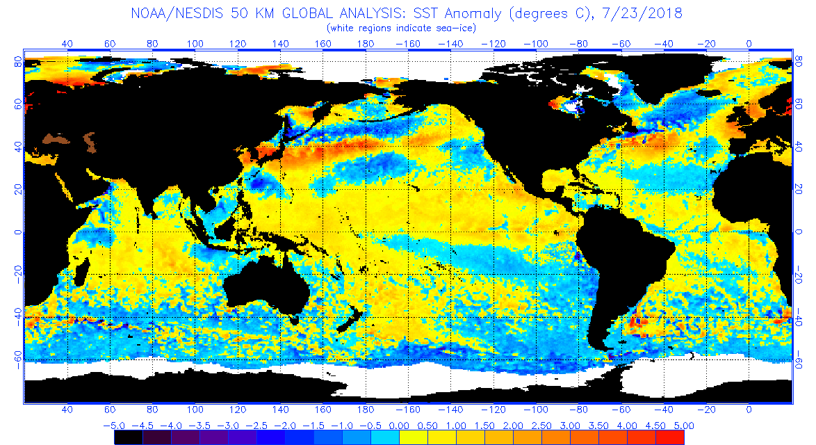
La Nada means 'nothing'. It's just the ENSO Neutral phase. Which currently is the case.

The current ENSO projections are in fact, heading towards Borderline or Weak Nino (based on BoM standards). This correlates with -AO/-NAO, which as the OP elludes to, increases the chance of snowfall in the East (though I still don't get the obsession with Bastardi, in this changing environment)
figure4-4.png
In addition to this, we are still in a negative QBO phase, we may still be in that phase in winter. This supports a -AO/-NAO winter, but it is currently slowly changing towards a positive QBO, that would improve Western snowfall chances. The solar situation also supports a -AO/-NAO (better for the East), and then there is also the interesting volcanic activity. For those who don't know, a large-scale, either high sulfur level, or stratospheric(very high into the atmosphere) volcanic explosion can increase snowfall chances substantially. And decreases your chance of sunny days.

The oceanic temperature gradients in the Pacific and Atlantic could also be something to watch for funneling of snow bearing systems and atmospheric rivers (latter referring to Pacific Ocean). Ineresting to see the ice cover remaining higher than expected, as said that could induce Greenland Blocking which would mean a -NAO. High North American Snow Cover induces a more +AO setup, that would help the Western slopes. Vice versa with high Greenland snow cover, through different mechanisms. Certainly an interesting setup, will wait for details to firm up though before making any big calls.
 
Last edited:
Thread Starter
TS
jack97

jack97

Out on the slopes
Skier
Joined
Jul 7, 2017
Posts
924
Yes, the potential for Greenland blocking is interesting. Furthermore, the winter NAO going negative, this setup was predominant back the 1960s

2000px-Winter-NAO-Index.svg.png
 
Last edited:

Sponsor

Staff online

Top