• For more information on how to avoid pop-up ads and still support SkiTalk click HERE.

California/Nevada Heavenly upper California GE trails view

SSSdave

life is short precious ...don't waste it
Skier
Joined
Sep 12, 2017
Posts
2,516
Location
Silicon Valley
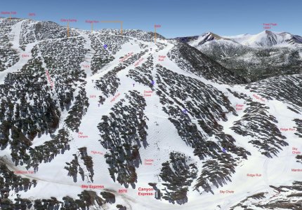
Created this Google Earth 3-D image of the upper California side of Heavenly that tends to be confusing because of the current whole resort trail map, and awkward terrain layout with limited longer fall lines on runs from its early ski resort era.
(mouse select to enlarge)
Heavenly-California-GE.jpg


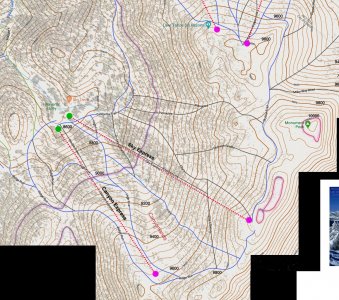
The below is a small crop from a custom topo resort I made.
Heavenly-California-topo.jpg
 
Last edited:

New2

Out on the slopes
Skier
Joined
May 3, 2017
Posts
729
Location
Spokane
That looks great! But the lift on the right in your first image is "Canyon Express," right? You have it labelled "Comet Express."
 
Thread Starter
TS
SSSdave

SSSdave

life is short precious ...don't waste it
Skier
Joined
Sep 12, 2017
Posts
2,516
Location
Silicon Valley
Thanks @New2. Corrected and loaded updated map above.

Note, RIDGE RUN routes all the way back to the lift base because some runs have combined run sections as shows on the Navigate Your Way Map (NYWM) Heavenly page. SKY CHUTE begins outside the image at top of the Powderbowl lift and routes to the Sky Express base combining with RIDGE RUN. The reason they did so, was in order to provide understandable single named trail directions for the many that are traveling to the upper mountain via Powderbowl lift. Thus the lower short section of RIDGE RUN is also SKY CHUTE. Likely also part of their on slope trail signage.

Note on my GE map, the purple T's are some trail sections not in fall lines. The blue R's are the forest cut from the old removed Ridge chair that has value knowing about on fresh powder days.

Another confusing Winter Map (James Niehues) feature is what they are now map naming SKY CANYON that years ago was CANYON. On their JH map, that shows as a black square run that is incorrect as it is a blue gradient that was always often groomed as part of the wide CANYON trail. What is black and often skied is down in the never groomed ravine just a bit through the trees east. Thus JH apparently updating their map for 2023 was given some incorrect information with Sky Canyon that ravine run. Also is near the Sonny tree collision site. Also beware when skiing down CANYONLANDS where I show a purple T, the fall line continues into the ravine and many inadvertently go that way. Instead one needs to stay fully skier's left up high out of the gully traversing along what is now a combined LIZ'S to reach SKY CANYON.

Another issue just above the Sky Express lift is on the JH map, a non-existent second High Five eastern split near the bottom and a wide open area where LIZ'S and HIGH FIVE combine. Very obvious on my Google Earth map but on the JH Winter Trail map just left of the CANYON in SKY CANYON text, shows a large forested blob that was there years ago but got logged off.

I suspect Heavenly (???) already knows about some of these issues and the next iteration of the winter trail map will straighten out issues. The above custom topo crop is part of a 4743x5231 full Heavenly resort map I print at 16.5x18.2 inches, that I could sell as a chump change product at ski shops if some printing business has interest. Given Photoshop and Caltopo layers have been creating custom high detail topographic maps for years, mainly for my summer Sierra Nevada backpacking. The gray areas are trees that were taken from a NAIP satellite layer. Useful for fresh powder skiing areas of out of trail sight sparse trees.
 

Sponsor

Staff online

Top