February 23, 2020
Day 21
Skiers: Carla
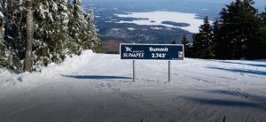
Mount Sunapee is the largest ski resort in southern NH. Boasting a 1,510’ vertical drop and 67 trails over 233 acres. Initially developed in 1948 and operated by the State of NH, Sunapee is now operated by Vail Resorts and is part of the Epic Pass. I used my SkiNH voucher for my ticket, while Tim paid the weekend rate at the ticket window.

Summit View of Lake Sunapee
The weather today was gorgeous, a high of 40 with bright sunny skies. The region received much needed snowfall over the previous week and conditions were outstanding. Beautiful packed powder, absence of ice, and full mountain coverage including the glades.
I have not visited Sunapee since the mid-80’s and was pleasantly surprised when we arrived. There are two base lodges on opposite ends of the parking area. The original Spruce lodge, and the newer Sunapee Lodge. This is where we made camp to boot up for the day.

View looking uphill from the parking area, Lynx race area central
We started out on the North Peak Triple to the midmountain, and skied Upper Hansen-Chase to Chase Ledges, to Hansen-Chute to access the Sunapee Express Quad. Our goal was to reach the Sunbowl area and it took a little navigating to make our way there. Wow did Sunbowl deliver! Dark lenses and sunscreen required. Once we located the Sunbowl Express Quad we enjoyed several runs on Wingding, Stovepipe, Skyway and Cataract before taking a midmorning break inside the Summit Lodge.

Inside the Cataract Glades, Sunbowl area
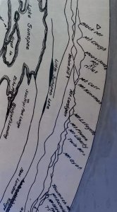
The Summit Lodge is a classic New England style ski lodge with a central stone fireplace and a wraparound deck. The architecture inside features artistic works produced by NH craftsmen adding warmth, beauty, and unique character. On the upper level of this lodge I discovered a great circular map the identified distant mountain and ski areas. I began conversing with a father and two children from the Boston area sitting near the map and he too was interested in the origins. All I had to go on was the inked name E. Fritz 1914 NH Forestry Commission.

Stone fireplace inside the Summit Lodge. “Symbolism in this ceramic plaque tells of man and his relation to nature. In it are standing four human figures. Two are male, darkish in tone, and two are female, whitish in tone. Each has been creatively abstracted into a variety of shapes, signs, and symbols. The four figures are the four seasons: the middle ones darkened with warm earth, the outer ones whitened with snow. Interspersed are small brilliant flashes of color we see on a day in nature—birds, fish, people. Over all is the red eye of the sun”. Designed and executed by Gerry Williams, Dunbarton, NH 1964.

Circular forestry map. This is approximately a 24” circumference and identifies distant mountains including Haystack, Mt. Snow, Stratton, Magic, Okemo, Ascutney, Killington, Pico, Franconia Ridge: Lafayette, Flume, Liberty, Tecumseh (Waterville Valley), Ragged, Crotched, Temple, Waschusett. This is just fascinating!

Close up view of Franconia Ridge

Close up view noting scale: 3 miles = 1 inch
Back on the mountain we skied all trails on skiers left including Upper Blast-Off, Upper Ridge, & Outer Ridge. Tim explored the Ridge Glades but I elected to stay on piste. The views were stunning from this side of the mountain. Then we worked our way back to the Summit central area to Bonanza, Westside, and through Hawes Hideout Glades. I played in these glades and they were fun! Not as tight as Cannon’s glades, but equally steep.

View of Lake Sunapee from Upper Ridge
We took a break for lunch inside Goosefeathers Pub located in the Spruce Lodge. Great menu including the daily special: an open-faced turkey sandwich with stuffing and cranberry sauce. Paired with a pint of Switchback it was delicious!

Spruce Lodge including rental area and Goosefeathers Pub
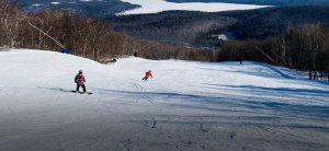
We spent the afternoon skiing Flying Goose, Goosebumps, and Eggbeater. Rinse and repeat. Goosebumps was my favorite trail of the day, not just because it was steep and fast, but because it was groomed with rolling turns and hills that I found to be engaging and thrilling.

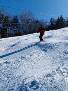
Tim skiing down Goosebumps. Look at the beautiful smoky powder

Tim skiing the bumps on Upper Flying Goose

Bumps on Upper Flying Goose as seen from the North Peak Triple
We did not ski the South Peak Learning Area today but did marvel at its size, lift access, and variety of trails. We also noted a sizeable terrain park on skiers right from the Eggbeater trail.

Sunapee learning area as viewed from Chipmunk. Note how large this is, and it is completely separate from the main mountain

I love this heart shaped park feature!
Overall impression: Sunapee offers a nice variety of terrain for all levels of skiers. Views are breathtaking and there are multiple lodge and lunch options available. Lifts are swift, lines were minimal, and overall, we had a fantastic ski day.
Snowy Wishes,
Carla Frontfive
End Note: this forestry map indeed was hand inked in 1914 by Emanuel Fritz. I did some sleuthing and discovered that in total 27 maps were made using the patented “New Hampshire Relief Alidade”. The technique is fascinating; here is a link to the 1915 Biennial Report of the Forestry Commission in the UNH archives. Maps discussed on pages 20-23. https://extension.unh.edu/resources/files/Resource006141_Rep8786.pdf
Additional sleuthing was required to actually locate the 27 maps. I have successfully found links to several in the Dartmouth archives including the Sunapee map that sparked my interest. I am planning on printing an enlarged copy to frame and hang in my ski home in Lincoln.
View from tower, Mt. Sunapee map made by the N.H. Forestry Commission for use in locating forest fires :: The Granite State in Maps, 1756-2003
View from Mt. Kearsarge (south) Forest Fire Lookout Station :: The Granite State in Maps, 1756-2003
View from Mt. Croydon Forest Fire Lookout Station :: The Granite State in Maps, 1756-2003
View from Smarts Mt. forest fire lookout station, N.H. Forestry Dept., 1917:panorama, by E.S. Atkinson :: The Granite State in Maps, 1756-2003
Day 21
Skiers: Carla
Mount Sunapee is the largest ski resort in southern NH. Boasting a 1,510’ vertical drop and 67 trails over 233 acres. Initially developed in 1948 and operated by the State of NH, Sunapee is now operated by Vail Resorts and is part of the Epic Pass. I used my SkiNH voucher for my ticket, while Tim paid the weekend rate at the ticket window.
Summit View of Lake Sunapee
The weather today was gorgeous, a high of 40 with bright sunny skies. The region received much needed snowfall over the previous week and conditions were outstanding. Beautiful packed powder, absence of ice, and full mountain coverage including the glades.
I have not visited Sunapee since the mid-80’s and was pleasantly surprised when we arrived. There are two base lodges on opposite ends of the parking area. The original Spruce lodge, and the newer Sunapee Lodge. This is where we made camp to boot up for the day.
View looking uphill from the parking area, Lynx race area central
We started out on the North Peak Triple to the midmountain, and skied Upper Hansen-Chase to Chase Ledges, to Hansen-Chute to access the Sunapee Express Quad. Our goal was to reach the Sunbowl area and it took a little navigating to make our way there. Wow did Sunbowl deliver! Dark lenses and sunscreen required. Once we located the Sunbowl Express Quad we enjoyed several runs on Wingding, Stovepipe, Skyway and Cataract before taking a midmorning break inside the Summit Lodge.
Inside the Cataract Glades, Sunbowl area
The Summit Lodge is a classic New England style ski lodge with a central stone fireplace and a wraparound deck. The architecture inside features artistic works produced by NH craftsmen adding warmth, beauty, and unique character. On the upper level of this lodge I discovered a great circular map the identified distant mountain and ski areas. I began conversing with a father and two children from the Boston area sitting near the map and he too was interested in the origins. All I had to go on was the inked name E. Fritz 1914 NH Forestry Commission.
Stone fireplace inside the Summit Lodge. “Symbolism in this ceramic plaque tells of man and his relation to nature. In it are standing four human figures. Two are male, darkish in tone, and two are female, whitish in tone. Each has been creatively abstracted into a variety of shapes, signs, and symbols. The four figures are the four seasons: the middle ones darkened with warm earth, the outer ones whitened with snow. Interspersed are small brilliant flashes of color we see on a day in nature—birds, fish, people. Over all is the red eye of the sun”. Designed and executed by Gerry Williams, Dunbarton, NH 1964.
Circular forestry map. This is approximately a 24” circumference and identifies distant mountains including Haystack, Mt. Snow, Stratton, Magic, Okemo, Ascutney, Killington, Pico, Franconia Ridge: Lafayette, Flume, Liberty, Tecumseh (Waterville Valley), Ragged, Crotched, Temple, Waschusett. This is just fascinating!
Close up view of Franconia Ridge
Close up view noting scale: 3 miles = 1 inch
Back on the mountain we skied all trails on skiers left including Upper Blast-Off, Upper Ridge, & Outer Ridge. Tim explored the Ridge Glades but I elected to stay on piste. The views were stunning from this side of the mountain. Then we worked our way back to the Summit central area to Bonanza, Westside, and through Hawes Hideout Glades. I played in these glades and they were fun! Not as tight as Cannon’s glades, but equally steep.
View of Lake Sunapee from Upper Ridge
We took a break for lunch inside Goosefeathers Pub located in the Spruce Lodge. Great menu including the daily special: an open-faced turkey sandwich with stuffing and cranberry sauce. Paired with a pint of Switchback it was delicious!
Spruce Lodge including rental area and Goosefeathers Pub
We spent the afternoon skiing Flying Goose, Goosebumps, and Eggbeater. Rinse and repeat. Goosebumps was my favorite trail of the day, not just because it was steep and fast, but because it was groomed with rolling turns and hills that I found to be engaging and thrilling.
Tim skiing down Goosebumps. Look at the beautiful smoky powder
Tim skiing the bumps on Upper Flying Goose
Bumps on Upper Flying Goose as seen from the North Peak Triple
We did not ski the South Peak Learning Area today but did marvel at its size, lift access, and variety of trails. We also noted a sizeable terrain park on skiers right from the Eggbeater trail.
Sunapee learning area as viewed from Chipmunk. Note how large this is, and it is completely separate from the main mountain
I love this heart shaped park feature!
Overall impression: Sunapee offers a nice variety of terrain for all levels of skiers. Views are breathtaking and there are multiple lodge and lunch options available. Lifts are swift, lines were minimal, and overall, we had a fantastic ski day.
Snowy Wishes,
Carla Frontfive
End Note: this forestry map indeed was hand inked in 1914 by Emanuel Fritz. I did some sleuthing and discovered that in total 27 maps were made using the patented “New Hampshire Relief Alidade”. The technique is fascinating; here is a link to the 1915 Biennial Report of the Forestry Commission in the UNH archives. Maps discussed on pages 20-23. https://extension.unh.edu/resources/files/Resource006141_Rep8786.pdf
Additional sleuthing was required to actually locate the 27 maps. I have successfully found links to several in the Dartmouth archives including the Sunapee map that sparked my interest. I am planning on printing an enlarged copy to frame and hang in my ski home in Lincoln.
View from tower, Mt. Sunapee map made by the N.H. Forestry Commission for use in locating forest fires :: The Granite State in Maps, 1756-2003
View from Mt. Kearsarge (south) Forest Fire Lookout Station :: The Granite State in Maps, 1756-2003
View from Mt. Croydon Forest Fire Lookout Station :: The Granite State in Maps, 1756-2003
View from Smarts Mt. forest fire lookout station, N.H. Forestry Dept., 1917:panorama, by E.S. Atkinson :: The Granite State in Maps, 1756-2003